【翻譯】條條大路通羅馬─關於羅馬道路的小知識
原文來自http://www.history.com/news/history-lists/8-ways-roads-helped-rome-rule-the-ancient-world
因為翻到一半覺得這文章的論點還不錯,大大激發我對羅馬道路的興趣,雖然有買相關的書,但其實因為私心的關係我只有看西班牙的部份(遮臉),所以一邊翻譯也一邊看了許多資料,學到非常多。
另外這是第一次翻譯這麼長的文章,認識我的人都知道我英文很差,做這件事純粹只是對羅馬的愛,這篇文翻的很辛苦,一堆工程+古羅馬專有名詞,查字典查到吐血,另外最大的問題在於明明看的懂句子卻不知如何適切地用中文表達,所以附上原文請大家來鞭我><

8 Ways Roads Helped Rome Rule the Ancient World
道路幫助羅馬人統治古代世界
By Evan Andrews
Roadways were the lifeblood of Ancient Rome. Over the course of 700 years, the Romans built more than 55,000 miles of paved highways throughout Europe—enough to encircle the globe. These engineering marvels ensured the swift movement of goods, soldiers and information across the Empire, and played a crucial role in tightening Rome’s grasp on the Mediterranean Basin. Explore eight reasons why this remarkable transit system helped unite the ancient world.
道路是古羅馬的命脈,在過去700多年間,羅馬人建造總長超過五萬五千公里、鋪遍歐洲的大道,長度足以環繞整個地球。這些令人驚訝的工程確保了貨物、士兵以及訊息在羅馬帝國中快速流通,並且在羅馬加強掌控地中海區域扮演著至關重要的角色。從下列八個方式,探索這些了不起的交通系統如何連結整個古代世界。
1. They were the key to Rome’s military might.
羅馬軍力的關鍵
The first major Roman road—the famed Appian Way, or “queen of the roads”—was constructed in 312 B.C. to serve as a supply route between republican Rome and its allies in Capua during the Second Samnite War. From then on, road systems often sprang from Roman conquest. As the legions blazed a trail through Europe, the Romans built new highways to link captured cities with Rome and establish them as colonies. These routes ensured that the Roman military could out-pace and out-maneuver its enemies, but they also aided in the everyday maintenance of the Empire. Reduced travel time and marching fatigue allowed the fleet-footed legions to move as quickly as 20 miles a day to respond to outside threats and internal uprisings. Even the most isolated parts of the Roman world could expect to be swiftly supplied or reinforced in the event of an emergency, lessening the need for large and costly garrison units at frontier outposts.
羅馬第一條主道路─著名的阿庇安大道,又稱為「道路女王」,建於西元前321年,此大道在第二次薩摩奈戰爭期間(Samnite)是做為羅馬共和國與盟邦卡普阿(Capua)的補給道路,從那時起,道路系統經常隨者羅馬的征服而擴散。當軍團在歐洲開闢道路(blazed a trail),羅馬人就會建立新的大道,將被佔領的城市與羅馬連結,並把這些城市建立為殖民地。這些道路確保羅馬軍力可以在速度和機動性上勝過他的敵人,但他們也協助帝國的日常維護。減少了旅行時間和行軍疲勞,讓疾走的軍團的步行速度達到每日20公里,以便快速反應帝國外部的威脅與內部的暴動。甚至在羅馬最孤立的地區,也能迅速因應緊急的情況,減少在前線基地的哨所、及高成本的駐軍基地。
補充
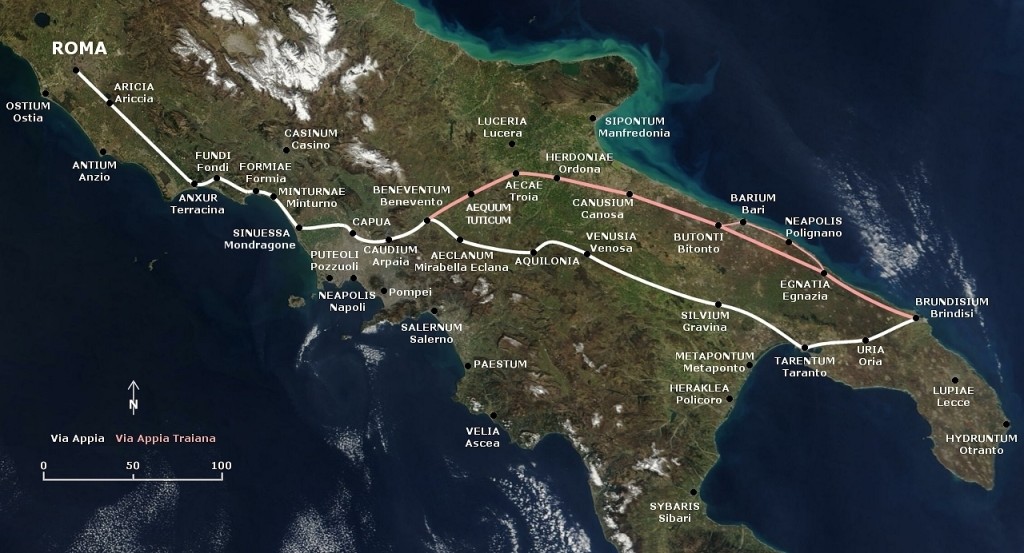
阿庇安大道Appian Way(拉丁文:Via Appia)
羅馬第一條道路,有詩作稱頌:
Appia teritur regina longarum viarum
“the Appian way is the queen of the long roads”
阿庇安道路是長路中的女王
阿庇安大道示意圖
阿庇安大道大多變成了現代公路, 現在羅馬保存了部分的遺跡。
2. They were incredibly efficient.
難以置信的高效率
Since Roman roads were designed with speed of travel in mind, they often followed a remarkably straight trail across the countryside. Land surveyors, or “gromatici,” began the building process by using sighting poles to painstakingly chart the most direct route from one destination to another. The resulting roads often shot straight up steep hills, and small bridges and tunnels were built to ensure the path could traverse rivers or pass right through mountains. Even in instances where the road was forced to divert from its course, the Romans typically opted for sharp turns and switchbacks over sweeping curves to preserve their arrow-straight design. Britain’s Fosse Way, for example, only veered a few miles off course over its entire 180-mile distance.
羅馬道路以旅行速度為設計考量,他們通常依循一個超直的道路穿過鄉村。開始建設道路前,土地測量師(gromatici)利用瞄準桿(sighting poles)精心繪製從起點到終點間最直的路徑。由此產生的道路通常筆直地穿過陡峭的山;小橋和隧道則是建來確保路徑能夠穿過河或是穿越群山。即使在道路被迫轉向情況下,羅馬人通常選擇急轉彎,或Z型的道路去取代大幅度彎曲的曲線,以維護他們的中規中矩的設計,舉例來說,英格蘭的佛斯大道(Fosse Way),在全長180公里的距離,只有少許的哩數有偏離原本的路徑方向。
補充
※瞄準桿
在古羅馬,這個勘測儀器稱作groma,由一根木棒製成,在木棒頂端有兩根十字交叉的木條與木棒垂直相交,在十字交叉木條的兩端垂著垂線。

※gromatici:古羅馬對土地測量師的稱呼,可參見Gromatici
※Fosse Way(佛斯道路)
道路起自埃克塞特經賽倫塞斯特至林肯。原為羅馬人第一步征服英國(約西元47)時的邊界線標誌。這條道路特別的地方,就是幾乎都是直線,充分體現羅馬人對道路的精神。
Fosse Way示意圖

3. They were expertly engineered.
熟練的工程技術
Roman builders used whatever materials were at hand to construct their roads, but their design always employed multiple layers for durability and flatness. Crews began by digging shallow, three-foot trenches and erecting small retaining walls along either side of the proposed route. The bottom section of the road was usually made of leveled earth and mortar or sand topped with small stones. This was followed by foundation layers of crushed rocks or gravel cemented with lime mortar. Finally, the surface layer was constructed using neatly arranged blocks made from gravel, pebbles, iron ore or hardened volcanic lava. Roads were built with a crown and adjacent ditches to ensure easy water drainage, and in some rainy regions they were even nestled on raised berms known as “aggers” to prevent flooding.
羅馬建築師通常利用手邊材料來建設道路,設計為了耐久和平坦,採用了多層結構。技術人員先沿著規劃的路徑兩旁,挖淺的,三英呎長的溝,架設小型的擋土牆(retaining walls)。最底層通常平鋪泥土、沙漿或沙子,上面覆蓋小石頭。其次的基底是碎石或礫石,用石灰漿(lime mortar)黏合,最後,表面層用礫石,卵石,鐵礦石或硬化的火山熔岩整齊排列。道路建成拱型,並有溝渠方便排水,在一些多雨地區,道路甚至坐落在提高的護堤“aggers”,以預防洪水氾濫。
補充
※羅馬道路的舖設
有鑑於這段一定會讓人看的霧煞煞,我找到的文獻也大多是文字敘述,這部份我覺得鹽野七生的說明做的最好,故借用她的圖,原圖載自《羅馬人的故事X─條條大道通羅馬》

※crown
這個字查字典只有皇冠等的意思,但在工程學上指的是「拱」狀的,在這裡指稱的是羅馬道路微微拱起的弧度。(特別提出來是因為要不是翻過資料再來看,根本看不懂這啥意思)
4. They were easy to navigate.
易於確認方向
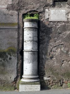
As the made their way down one of Rome’s many roadways, weary travelers could guide themselves by a detailed collection of mile markers. Much like the road signs on modern interstates and freeways, these stone pillars gave the distance to the nearest town in Roman miles and instructed the traveler on the best places to stop. They also provided information on when the road was built, who constructed it and who last repaired it. To embody the idea that “all roads lead to Rome,” the Emperor Augustus even saw that a so-called “golden milestone” was placed in the Roman Forum. Cast from gilded bronze, this monument listed the distance to all the city’s gates and was considered the convergence point of the Empire’s road system.
沿著其中一條羅馬道路前行,疲憊的旅客可藉由一系列詳細的里程碑(mile markers)來獲得引導,就像現代洲際公路或高速公路上的路標,這些石柱給出最近城鎮的距離,並指示旅人最適宜的休息點。里程碑也提供了這條道路何時興建的訊息,由誰主建、由誰修復。為了體現《條條大路通羅馬》的想法,奧古斯都皇帝樹立了「黃金里程碑」,此碑位於在羅馬廣場,由鎏金青銅製作,這個紀念碑列出了從此地到其他城市城門的距離,被認為是羅馬道路系統的匯流處。
※Milliarium Aureum
即黃金里程碑,由奧古斯都設立,作為起點的里程碑,現在僅存地基,許多歐洲國家有類似的設計,例如西班牙首都馬德里在太陽門廣場設立了0km碑,就是模仿羅馬的黃金里程碑。

5. They included a sophisticated network of post houses and roadside inns.
驛站與旅館的複雜路網
Along with road signs and mile markers, Roman roads were also lined with state-run hotels and way stations. The most common of these ancient rest stops were the horse changing stations, or “mutationes,” which were located every ten miles along most routes. These simple posthouses consisted of stables where government travelers could trade their winded horse or donkey for a fresh mount. Switching horses was especially important for imperial couriers, who were tasked with carrying communications and tax revenues around the Empire at breakneck speed. By stopping off at multiple posthouses, couriers could move as far as 60 miles in a single day. Along with the more common “mutationes,” travelers could also expect to encounter roadside hotels, or “mansiones,” roughly every 20 miles. Each “mansio” offered basic lodgings for people and their animals as well as a place to eat, bathe, repair wagons or even hire a prostitute.
沿著路標與里程標誌,羅馬道路也林立著國營旅館和中途休息站,這些在古代常見的休息站是換馬站,又稱為mutationes,以大部分的路來說,約每十里出現一座,是簡單的驛站,內有馬廄提供信使者可以換乘馬匹或驢子。換乘馬匹對帝國信使特別重要,讓他們用最快的速度從帝國各處攜帶信息和稅收。透過驛站,信使的速度可達到每日60公里。
除了常見的mutationes,旅人也可以選擇路邊的小旅館。又稱mansiones,大約每20公里就會出現,mansio提供了給人們及座騎基本的寄宿、飲食和盥洗服務,另外還能修復武器,或是嫖妓。
6. They were well-protected and patrolled.
極佳的的保護和巡邏。
To combat the activities of thieves and highwaymen, most Roman roads were patrolled by special detachments of imperial army troops known as “stationarii” and “beneficiarii.” These soldiers manned police posts and watchtowers in both high traffic and remote areas to help guide vulnerable travelers, relay messages and keep an eye out for runaway slaves. They also doubled as toll collectors. Like modern highways, Roman roads were not always free of charge, and troops were often waiting to levy fees or taxes on goods whenever the route reached a bridge, mountain pass or provincial border.
為了對抗盜賊和強盜,大多數的羅馬的道路由特殊的帝國軍團分隊巡邏,他們通常被稱為stationarii或beneficiarii,這些士兵駐守在高流量和偏遠地區的警崗和瞭望塔,幫助和指引易受攻擊的旅客、轉達信件和留意逃跑的奴隸。他們也兼任收費員,就像現代高速公路的收費站收費員。羅馬道路不是全部免過路費,每當軍隊到達一座橋,山口或省際邊界時,經常為了徵收貨物稅而等待。
7. They allowed the Romans to fully map their growing empire.
羅馬人以此標記出其日益強大的帝國。
Much of what historians know about Rome’s road system comes courtesy of a single artifact. Named for its medieval owner, Konrad Peutinger, the Peutinger Table is a 13th century copy of an actual Roman map created sometime around the 4th century A.D. This eye-catching atlas was drawn on a 22-foot-long collection of parchment and shows the entire Roman world in full color along with several thousand place names. Cities are illustrated with sketches of small houses or medallions, but the map also includes the locations of lighthouses, bridges, inns, tunnels, and—most importantly—the Roman highway system. All the major Roman roads are listed, and the map even gives the distances between various cities and landmarks. The Peutinger map has proven indispensable to scholars studying the Roman transit system, yet historians still debate its original purpose. Some have claimed it was a field guide for government figures traveling on official business, while others contend it was displayed in an imperial palace.
許多歷史學家對羅馬的道路系統的認知通常來自單一文物─佩烏丁格地圖(Peutinger table),該地圖的名字來自其中世紀擁有者 Konrad Peutinger,佩烏丁格地圖根據是四世紀的羅馬地圖,在13世紀完成的副本,這個搶眼的地圖繪製在約700公尺長的羊皮紙,以全彩及數千個地名呈現整個羅馬世界。城市繪製成小房子或獎章,但地圖還包括燈塔,橋樑,旅館,隧道(洞穴),以及最重要的 – 羅馬公路系統。所有主要羅馬道路都列出來,甚至標示出各個城市和地標之間的距離。佩烏丁格地圖是研究羅馬交通系統的學者不可或缺的,但史學家仍在爭論它的初衷。有些人宣稱這是政府計算商務行程的圖鑑,而另一些人認為這曾被展示在皇宮中。
補充
※Peutinger table佩烏丁格地圖
著名的羅馬地圖,之前的在台灣的羅馬展中曾經出現過電子檔的複製品,原圖超級長,下圖是局部

8. They were built to last.
經久耐用
Thanks to their ingenious design and careful construction, Roman roads remained technologically unequaled until as recently as the 19th century. But while modern asphalt highways might offer a smoother ride than the Via Domitiana or the Appian Way, Rome’s 2,000-year-old roadways take the prize for durability. Many Roman roads were used as major thoroughfares until only recently, and some—including the Via Flaminia and Britain’s Fosse Way—still carry car, bike and foot traffic or serve as the guiding route for highways. Rome’s enduring engineering legacy can also be seen in the dozens of ancient bridges, tunnels and aqueducts still in use today.
由於其巧妙的設計和細心的建設,羅馬道路的技術直到19世紀前依然無與倫比。不過,雖然現代的柏油公路比多米蒂亞娜大道Domitiana,或阿庇安大道擁有更平穩的乘車經驗,羅馬已使用2000年的道路依然能得到經久耐用的獎項。許多羅馬道路直到近代,仍用來作為交通要道, 另外包括弗拉米尼亞大道(Flaminia)和英國的佛斯道路仍然提供汽車,自行車和步行使用,或作為高速公路的路線。羅馬的永恆的工程遺產,在至今在使用中的古橋、隧道、水渠依然可見。
Did You Know?
你知道嗎?
Rome’s first major road, the Appian Way, played a grisly role in the 1st century B.C. slave rebellion led by the gladiator Spartacus. When the Romans finally routed the rebel forces in 71 B.C., they crucified more than 6,000 captured slaves along the Appian Way’s entire 132-mile course from Rome to Capua.
羅馬的第一個主要道路阿庇安大道,在公元前1世紀以角鬥士斯巴達克斯為首的奴隸叛亂中,扮演了可怕的角色。羅馬人在公元前71年擊潰了叛軍,他們沿著阿庇安大道從羅馬到卡普的路徑,將6000多名捕獲的奴隸釘在十字架上,綿延132公里。
補充
如果大家對羅馬道路有興趣,又不想一直看英文(說真的我也不喜歡),目前台灣有有下列幾本相關書籍可以參考,但請記住,盡信書不如無書,多方閱讀資料、交叉比對才是追求學問的方向。
《羅馬人的故事X─條條大道通羅馬》
塩野七生
ISBN13:9789571440231。
這本是羅馬人的故事系列,但這本是獨立的內容,專門講羅馬的基礎建設,入門好懂,不過因為寫作角度的關係,鹽野七生非常推崇羅馬,感覺好像羅馬完全沒有缺點,即使如此,這套書還是值得推薦的好書。
《古羅馬的旅人》
作者:劉增泉
ISBN13:9789571171241
因為是以古代旅行為主題的書,所以會提到一部分羅馬道路的構成,這本書不厚,但可能需要一點羅馬史基礎才好上手,對古代羅馬人如何「出門」有興趣的話,可以看看。
《羅馬道路與羅馬社會》
ISBN13:9787516113813
作者:馮定雄
這本是簡體書,但是我目前在中文世界見過對羅馬道路介紹最詳盡的一本,我翻譯的這篇文章很多東西如果要細究,這本書不可不讀,裡面資料豐富,可惜圖片很少。
以上純個人心得分享,若有任何問題請留言給我,懇請大家指正(鞠躬)


